|
| |
| |
Area A/V
by Irmgard Hein |
|
| |
| |
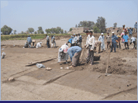
Area A/V is located at the north-eastern edge of the
mound of Tell el–Dabca, approx. 500 m
northeast of area A/I and A/II.
There is evidence of former archaeological investigations
in this area. Small pits are widespread throughout the
area, the average size of one being 1.5–2.0 ms x
0.7 ms, suggesting the work of a single digger. Such specific
pits are likeliest to be the relics of E. Naville’s
investigations from 1885, being labelled "Naville-pits"
as a result. Naville (1887, 21) described the on-the-ground
activities as follows: "I worked for more than
a month with about a hundred labourers in the area of
the enclosure and especially towards the western side,
and went down as far as the water allowed."
In 1987 a geological survey of the geomorphologic conditions,
using methods of investigating soil out of drill cores,
was conducted by J. Dorner (Dorner 1989). This went to
prove that area A/V was located at the southern fringe
of a turtle back of sand (gezira). As has been recently
demonstrable in the geomagnetic survey (see Forstner-Müller
and others, 2004), (>>geomagnetic
plan/survey).
A/V is part of a larger settlement area which had been
separated from the main Tell by a channel of water. The
features of the sherdage from the Dorner survey anticipate
settlement remains from the Late SIP period, in particular
ones tying in with Str. D/3 and D/2
(>>strata).
Due to the landlord’s intended agricultural use
of the area, the EAS suggested an investigation of the
plot which went on to be conducted by C. Hölzl, then
followed up by I. Hein under the auspices of M. Bietak
and J. Dorner. Mohammed Taher and Ibrahim Soliman attended
as representatives from the Egyptian Antiquities Authorities.
An area of 1800 m2 in 18 squares by 9.0 x 9.0
ms was excavated down to two to three levels, all of them
containing material from the Late Hyksos Period. Only
one square was tested on down to level 5, but work had
to stop because of rising groundwater. The material has
been published by I. Hein and P. Jánosi in the
volume Tell el-Dabca XI. |
|
| |
| |
Stratigraphy
Deep-level probes of square p/19 showed up layers tying
in with strata E/1 (shortly after inception of the Hyksos
Period) as far as Str. D/2 (final phase of the Hyksos
Period) on upper levels
(>>chronology strata). Later material was also found
either in pits cutting into these layers - albeit without
adjacent horizon - or at several spots just below the
surface, such as at Locus 145, bearing witness to activities
from later periods (str. post D/2, str. C, str. B). No
buildings from these late phases were traceable.
This material is proof that settlement activities started
relatively late in this eastern part of the Auaris/ Tell
el–Dabca town district, as opposed to areas A/II,
A/IV, F/I
or cEzbet
Rushdi where the earliest traces go back to the 12th
Dynasty. |
|
| |
| |
The earliest levels from area
A/V
In one square, A/V-p/19, the layers were explored as deeply
as possible, down to a depth of 3.60 m/NN. Because of
the high water table, it was not possible to delve further.
The lowest level contained settlement relics from the
early Hyksos Period tying in with str. E/1- E/2
(>>chronology strata).
It was from this phase that we found a house spanning
several building layers. Test drills NW of the square
showed, going down another 30 cms, the presence of settlements
starting to be built on the gezira. The initiation of
settlement activity can be linked to population growth
at the beginning of the Hyksos Period (15th Dynasty, approx.
1,620 B.C.). The apparently rapid increase in population
would have led to a shortage of space in the old town,
as can be interpreted from the situation in area
A/II. The result was expansion into inhabited zones
and the adjacent Gezira hill in the East. |
|
| |
| |
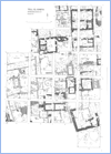
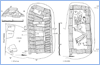
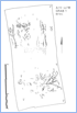
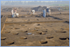
The Hyksos Period (str. E/1-D/2)
The settlement remains show houses loosely scattered around
the site, including only a few tombs within the area inhabited
(pic.1
- map of area A/V). The dwelling units show courtyards
as well as farming utensils and equipment, such as vessel
stands, kilns, silos etc. (pic.2). |
| |
|
|
| |
| |
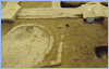
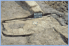
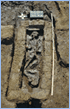
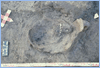
Tombs in the area
All the tombs have been looted. We found different kinds
of burials - single burials with offering deposits,
being common during the late Hyksos Period (pic.
3, pic.
4, pic.5,
pic.6
and pic.7).
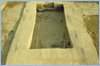
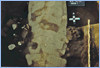
A large tomb construction with a tomb chamber was also
discovered
(pic. 8, pic.
9 and pic.
10).
This tomb, containing multiple burials, was built parallel
to the street and to the houses around. The rooms added
south and west of the area may possibly be another part
of the tomb structure. The burials had been constantly
plundered, leaving disjointed skeletal remains. The
chamber was paved with mud bricks overlaid by a thin
rubble layer which acted as the burial ground. |
|
| |
|
|
| |
|
|
| |
| |
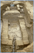
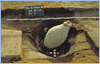
Children were usually buried in large pottery
containers, such as amphorae (pic.
11), within the housing confines, whilst a group of
multiple child burials dotted around a chamber tomb was
detected on square A/V-p/19 (pic.
12 und pic.
13). |
|
| |
|
|
| |
| |
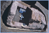
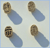
Finds
The pottery from area A/V offers a rich collection of
household and daily life pottery, in particular from the
end of the Hyksos Period. Some scarabs also date to this
period (pic.
14 and pic.
15). |
|
| |
|
|
| |
| |
A destruction level at the end of the occupation
phase, widely assumed to coincide with the end of the
Hyksos Period, failed to be detected. We can therefore
assume that the structures remained intact into the 18th
Dynasty. Objects datable from the early 18th Dynasty were
found in pits and disturbed areas, such as a bulky storage
jar (Zir) which presumably dates to the early 18th Dynasty
(pic.
16). |
|
| |
|
|
| |
| |
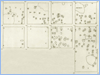
Ramesside Period (str. B)
A complete change in the settlement structures was traceable
from the end of the 18th Dynasty/early Ramesside Period
onwards when small pits started being regularly laid out
in rows, over the site, probably being the remnants of
a garden or a vineyard on that very spot (pic.
17 - garden leve and pic.
18). |
|
| |
|
|
| |
 |
| |
Bibliography: |
|
| |
|
Bietak, M.
|
| 1991 |
|
Tell el-Dabca V, 19–26. |
|
Dorner, J.
|
| 1989 |
|
Grabungsbericht Tell Tell el-Dabca,
Ägypten, ÖJh, 4 |
|
| 1994 |
|
Bericht über die Geländesondagen,
Ä&L 4, 11–15. |
|
| 1999 |
|
Bericht über die Geländesondagen, Ä&L
9, 82. |
|
Hein, I.
|
| 1992 |
|
Two Excavation Areas from Tell el-Dabca,
in: Sesto Congresso Internazionale di Egittologia,
Atti, Vol. 1, Turin, 1992, 249 – 253. |
|
Hein, I. and Jánosi, P.
|
| 2004 |
|
Tell el-Dabca XI. Areal A/V, Siedlungsrelikte
der Späten Hyksoszeit,. Verlag Österr.
Akademie der Wissenschaften, UZK XXI, Wien 2004.
Mit Beiträgen von: K. Großschmidt, K.
Kopetzky, L. Maguire, C. Mlinar, G. Philip, U. Thanheiser,
A. Tillmann. |
|
Jánosi, P.
|
| 1992 |
|
Hausanlagen der späten Hyksoszeit
und der 18. Dynastie in Tell el-Dabca
und cEzbet Helmi. In: Haus und Palast
im Alten Ägypten. Intenationales Symposium
8.-11. April 1992 in Kairo. ÖAW. Wien. 85-92.
|
|
Maguire, L. C.
|
| 1995 |
|
Tell el-Dabca, The Cypriot
Connection, in: Egypt, the Aegean and the Levant,
London, BMP, 54 – 65 |
|
Naville, E.
|
| 1887 |
|
The Shrine of Saft el Henneh and
the Land of Goshen. EEF Mem. 5. London. |
|
| |
|
|